
Wernigerode
Wernigerode | |
|---|---|
 Coat of arms | |
Location of Wernigerode within Harz district <imagemap>File: Wernigerode in HZ.png | 240x240px poly 219 211 212 209 203 217 200 215 200 208 204 204 202 198 201 191 206 187 206 180 201 176 203 165 216 164 226 165 227 161 226 157 231 150 236 148 235 142 242 143 239 146 245 162 251 164 255 167 254 174 247 181 243 182 241 191 233 200 221 200 Ballenstedt poly 93 162 94 153 104 150 99 145 102 134 112 132 112 116 110 106 104 106 103 97 105 90 112 92 113 85 132 88 129 98 140 96 139 104 131 105 134 119 145 121 155 120 167 123 163 131 154 136 154 147 161 147 159 162 153 162 154 167 151 171 147 167 143 175 132 174 127 166 123 167 118 169 105 160 Blankenburg (Harz) poly 197 121 199 114 204 114 210 108 225 108 225 117 223 125 230 133 225 138 217 132 209 133 204 130 203 127 Ditfurt poly 230 226 227 217 218 211 219 199 231 197 240 184 255 168 249 162 259 162 265 152 279 153 284 165 278 184 280 193 264 198 260 209 256 212 246 213 246 218 241 221 Falkenstein poly 175 59 180 59 181 60 182 60 182 59 196 60 196 65 197 66 201 66 198 69 195 69 192 71 191 73 190 74 190 75 189 75 188 76 189 80 189 82 188 82 184 79 184 78 182 79 182 78 181 78 180 79 180 80 179 79 179 78 178 77 177 78 177 74 175 74 175 70 174 69 174 68 175 67 174 60 Groß Quenstedt poly 110 68 110 59 122 58 135 60 159 61 172 58 173 68 176 77 186 80 187 73 198 66 206 78 195 85 187 89 176 93 168 123 157 120 146 121 135 119 131 105 139 105 142 95 131 97 133 88 118 88 119 72 110 66 Halberstadt poly 167 122 176 92 189 88 195 98 194 117 188 115 178 128 Harsleben poly 116 242 119 231 129 223 133 216 156 206 161 210 167 206 182 206 195 211 200 215 207 210 216 210 225 217 230 225 232 231 229 243 224 251 211 250 206 247 202 257 202 260 194 263 190 259 193 251 186 249 180 246 172 249 165 249 163 243 157 238 160 233 143 234 139 228 125 233 125 237 Harzgerode poly 226 117 224 100 235 91 250 98 246 102 246 107 235 115 230 113 226 119 Hedersleben poly 95 8 104 2 131 2 144 6 156 12 167 13 166 20 173 20 174 26 179 31 181 45 167 48 164 52 169 57 155 61 149 59 137 61 124 59 112 60 110 51 104 49 98 40 97 15 Huy poly 9 125 12 120 7 119 10 113 16 113 20 105 29 99 38 99 48 96 61 99 66 102 67 115 64 123 53 122 51 119 47 122 48 125 42 130 35 129 36 133 35 137 31 141 32 146 27 142 27 130 23 132 16 128 10 124 Ilsenburg poly 21 78 19 68 23 64 30 61 36 69 35 75 59 69 65 64 73 66 78 71 106 71 109 67 119 71 119 86 113 86 112 92 106 91 104 97 90 98 86 94 75 98 68 104 64 100 52 95 42 97 37 101 29 99 32 90 32 82 28 79 Nordharz poly 49 228 40 215 38 200 40 196 38 186 32 185 27 175 27 165 50 167 46 158 50 157 56 160 65 150 79 150 86 144 91 147 96 146 103 151 94 154 92 161 104 159 106 164 116 168 111 177 112 181 119 182 120 194 129 198 115 199 120 205 131 204 128 211 133 215 132 221 125 226 118 232 117 240 114 241 105 229 94 231 90 235 87 226 76 226 71 221 67 225 57 225 Oberharz am Brocken poly 3 33 11 48 16 45 22 56 28 53 32 56 29 60 37 68 36 76 46 72 58 69 64 64 73 64 77 70 87 72 106 71 109 67 109 61 112 59 110 51 105 50 98 40 97 14 95 8 73 8 52 7 31 11 33 21 29 22 24 31 14 31 10 27 Osterwieck poly 199 120 190 117 184 124 179 128 184 131 179 135 181 145 176 143 169 144 169 148 173 146 178 149 185 149 187 157 188 166 188 175 183 177 183 183 178 183 174 185 171 191 176 192 176 195 170 198 170 209 184 207 193 213 199 212 202 204 201 199 205 188 205 182 200 176 203 166 223 165 227 160 229 150 234 147 233 142 229 139 222 139 217 134 210 134 206 131 202 126 Quedlinburg poly 169 57 163 54 166 47 180 45 180 33 196 33 199 43 195 48 196 53 203 51 207 55 200 66 194 66 194 59 181 57 171 57 Schwanebeck poly 230 132 224 126 225 121 230 113 234 114 245 106 249 97 240 91 239 83 245 82 253 86 260 82 257 91 259 95 258 110 252 117 250 122 243 126 238 121 231 131 Selke-Aue poly 114 170 122 167 130 175 142 176 146 171 154 170 154 162 159 162 161 147 155 147 152 138 167 130 168 121 177 126 181 129 178 141 170 144 176 148 182 149 186 156 186 169 184 182 173 183 170 191 167 205 164 208 157 206 135 215 127 212 130 204 122 206 119 200 126 199 122 194 122 182 112 180 114 172 Thale poly 190 88 205 79 213 72 222 81 236 90 225 100 226 110 212 108 206 115 201 113 198 116 193 116 194 98 Wegeleben poly 27 165 13 160 10 154 10 142 8 128 10 125 16 131 26 131 26 142 31 148 32 140 37 135 35 128 41 129 52 121 63 123 68 115 66 105 76 98 85 95 89 99 104 97 104 106 109 107 112 112 111 123 114 132 104 135 99 145 90 147 86 143 78 149 66 151 56 161 50 156 44 157 50 166 39 167 34 165 27 166 Wernigerode desc bottom-right </imagemap> | |
 Wernigerode  Wernigerode | |
| Coordinates: 51°50′6″N 10°47′7″E / 51.83500°N 10.78528°E | |
| Country | Germany |
| State | Saxony-Anhalt |
| District | Harz |
| Government | |
| • Mayor (2022–29) | Tobias Kascha[1] (SPD) |
| Area | |
| • Total | 170.03 km2 (65.65 sq mi) |
| Elevation | 240 m (790 ft) |
| Population (2022-12-31)[2] | |
| • Total | 32,024 |
| • Density | 190/km2 (490/sq mi) |
| Time zone | UTC+01:00 (CET) |
| • Summer (DST) | UTC+02:00 (CEST) |
| Postal codes | 38855, 38879 |
| Dialling codes | 03943, 039455 |
| Vehicle registration | HZ, HBS, QLB, WR |
| Website | www.wernigerode.de |


Wernigerode (German pronunciation: [ˌvɛɐ̯nɪɡəˈʁoːdə]) is a town in the district of Harz, Saxony-Anhalt, Germany. Until 2007, it was the capital of the district of Wernigerode.[3] Its population was 32,181 in 2020.
Wernigerode is located southwest of Halberstadt, and is picturesquely situated on the Holtemme river, on the northern slopes of the Harz Mountains.[4] Wernigerode is located on the German Timber-Frame Road.
Geography
Location


The town lies at about 250 metres (820 ft) above sea level (NN) on the northeastern flank of the Harz Mountains in central Germany, at the foot of their highest peak, the Brocken, on the B 6 and B 244 federal highways and on the railway line from Halberstadt to Vienenburg that links the cities of Halle (Saale) and Hanover.
The River Holtemme flows through the town and, not far from its western gate, it is joined by the Zillierbach stream, which is also known as the Flutrenne near its mouth. North of the town the Barrenbach flows through several ponds and empties into the Holtemme in the village of Minsleben. The historic town centre consists of an old town and a new town (Altstadt and Neustadt). The town's borough includes Hasserode, Nöschenrode, the residential estates of Stadtfeld, Burgbreite and Harzblick as well as the villages of Benzingerode, Minsleben, Silstedt, Schierke and Reddeber.
The borough measures 9.5 kilometres (5.9 mi) from west to east and 6 kilometres (3.7 mi) from north to south. Its highest point is the Brocken, at 1,141 metres (3,743 ft) above NN, and its lowest is at 215 metres (705 ft).
The town lies on the German-Dutch holiday road known as the Orange Route.
The Northern Harz Boundary Fault crosses the borough along which runs the watershed between the Weser and Elbe rivers. To the north precipitation flows into the Weser, to the southeast, later northeast, waters flow into the Elbe. This fault line runs through the suburb of Hasserode to the west south west of the city centre and forms the town's castle hill to the south east of the city centre.
Town divisions
The town of Wernigerode is divided into the town itself, including the villages of Hasserode and Nöschenrode incorporated before 1994, and five villages with their own local councils that were integrated after 1994: Benzingerode, Minsleben, Reddeber, Schierke and Silstedt.[5]
Climate

Wernigerode is located in the Central European transition subzone of the temperate climatic zone.[6] Its average annual temperature is 9.5 °C (49.1 °F); its average annual precipitation is 500 millimetres (20 in).
The warmest months are June to August with average temperatures of 16.0 to 18.3 °C (60.8 to 64.9 °F) and the coldest are December to February at 1.1 to 2.1 °C (34.0 to 35.8 °F).
The most rain falls in July, on average 54 millimetres (2.1 in), the least in February, with 30 millimetres (1.2 in) on average.
The climate, more precisely the amounts of precipitation and temperatures, are influenced by the orographic rainfall caused by the Harz Mountains. Because the town lies in the rain shadow (leeward side) of the Harz, less precipitation falls here than in similar temperate regions without the protection of a mountain range. In addition the occasional föhn winds that occur result in an increase in temperatures.
| Climate data for Wernigerode (1991–2020 normals) | |||||||||||||
|---|---|---|---|---|---|---|---|---|---|---|---|---|---|
| Month | Jan | Feb | Mar | Apr | May | Jun | Jul | Aug | Sep | Oct | Nov | Dec | Year |
| Mean daily maximum °C (°F) | 4.5 (40.1) |
4.8 (40.6) |
8.9 (48.0) |
14.2 (57.6) |
18.2 (64.8) |
21.6 (70.9) |
24.2 (75.6) |
23.9 (75.0) |
19.2 (66.6) |
14.1 (57.4) |
8.6 (47.5) |
5.3 (41.5) |
14.2 (57.6) |
| Daily mean °C (°F) | 1.7 (35.1) |
1.6 (34.9) |
4.8 (40.6) |
9.1 (48.4) |
13.2 (55.8) |
16.5 (61.7) |
19.0 (66.2) |
18.2 (64.8) |
14.5 (58.1) |
10.2 (50.4) |
5.8 (42.4) |
2.7 (36.9) |
9.9 (49.8) |
| Mean daily minimum °C (°F) | −1.2 (29.8) |
−2.0 (28.4) |
0.6 (33.1) |
3.6 (38.5) |
7.5 (45.5) |
11.0 (51.8) |
13.2 (55.8) |
13.0 (55.4) |
9.4 (48.9) |
6.1 (43.0) |
2.4 (36.3) |
−0.5 (31.1) |
5.4 (41.7) |
| Average precipitation mm (inches) | 52.3 (2.06) |
35.9 (1.41) |
43.5 (1.71) |
32.0 (1.26) |
64.2 (2.53) |
47.0 (1.85) |
67.1 (2.64) |
54.8 (2.16) |
55.1 (2.17) |
41.3 (1.63) |
44.0 (1.73) |
46.9 (1.85) |
613.9 (24.17) |
| Average precipitation days (≥ 1.0 mm) | 17.7 | 14.0 | 15.0 | 11.6 | 14.3 | 13.4 | 15.5 | 14.0 | 13.3 | 13.9 | 15.2 | 17.5 | 176.3 |
| Average relative humidity (%) | 80 | 77.3 | 73.9 | 67.2 | 68.6 | 68.2 | 66.0 | 67.2 | 73.1 | 78.7 | 82.1 | 80.5 | 73.6 |
| Mean monthly sunshine hours | 62.6 | 87.4 | 139.0 | 182.0 | 205.0 | 215.3 | 223.9 | 203.4 | 151.4 | 122.9 | 67.7 | 51.3 | 1,743.7 |
| Source: World Meteorological Organization[7] | |||||||||||||
Wernigerode has a snow load class of 3 according to the German industrial standard, DIN 1055.
History


Wernigerode was the capital of the medieval County of Wernigerode and Stolberg-Wernigerode. In 1815, after the Napoleonic Wars, it became part of the Prussian Province of Saxony. The Hasseröder brewery was founded in Wernigerode in 1872.
After World War II, Wernigerode was included in the new state Saxony-Anhalt within the Soviet occupation zone (relaunched in October 1949 as the German Democratic Republic/East Germany). During the Communist years, the town was very close to the inner German border. Wernigerode became part of the restored state of Saxony-Anhalt in 1990 after German reunification.
Emergence of the town
There are no written sources confirming exactly when the town was established. According to the latest research – for example, by Eduard Jacobs and Walther Grosse – there were no early relations with the Abbey at Corvey (Weser) and the abbot there, Warin, instead the town name suggests it was a protected clearance settlement.
The first area to be settle was the Klint, where there was a lowland castle, the so-called Schnakenburg. In 1805 the ruins of this castle site were demolished. The only part remaining is Haus Gadenstedt at Oberpfarrkirchhof 12 which dates to the year 1582. At the time of the first settlelement there was still ancient forest, typical of the Harz, on the heights of the Klint, which had first to be cleared, hence the suffix rode in the town name which means 'clearing'.
The town was first mentioned in the records in 1121 in connection with Count Adalbert of Haimar who had moved here from the region near Hildesheim and henceforth was titled the Count of Wernigerode. On 17 April 1229 the settlement was granted town rights along the lines of that for Goslar. In 2004 Wernigerode celebrated the 775th anniversary of that occasion.
As a result of the immigration of new townsfolk from the surrounding villages a new settlement, later called Neustadt, grew up on the northeastern edge of the old town. It was a farming settlement that lay outside the walls of the old town. St. John's Church was built as the parish church of Wernigerode's Neustadt in the last third of the 13th century in the Romanesque style.
Early rulers
The counts of Wernigerode, who can be traced back to the early 12th century, were successively vassals of the margraves of Brandenburg (1268), and the archbishops of Magdeburg (1381). On the extinction of the family in 1429 the county fell to the counts of Stolberg, who founded the Stolberg-Wernigerode branch in 1645. The latter surrendered its military and fiscal independence to Prussia in 1714, but retained some of its sovereign rights till 1876. The counts were raised to princely rank in 1890.[4]
Mayors
- Runden, c. 1640[8]
- Ludwig Gepel, 7 January 1921 to 6 January 1933
- Ulrich von Fresenius (1 September 1888; died 12 November 1962), 10 January 1933 to 20 April 1945
- Max Otto (1889–1969), SPD/SED, 20 April 1945 to 1951
- Gustav Strahl, 1951 to 1962
- Martin Kilian, SED, 24 October 1962 to 1990
- Herbert Teubner, CDU, 1990 to 1991
- Horst-Dieter Weyrauch, CDU, 1991 to 1994
- Ludwig Hoffmann, SPD, 1994 to 31 July 2008
- Peter Gaffert, independent, since 1 August 2008
- Tobias Kascha, SPD, since 1 August 2022
Population statistics
- 1595: 2,500
- 1806: 3,700
- 1845: 5,000
- 1869: 7,000
- 1886: 9,000
- 1895: 10,662
- 1904: 12,000
- 1914: 18,000
- 1957: 33,353
- 1990: 37,000
- 2006: 33,871
- 2007: 34,413
- 2008: 35,041
- 2009: 34,673
Architecture
,_by_Klugschnacker_in_Wikipedia_(14).JPG)
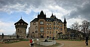
Wernigerode contains several interesting Gothic buildings, including a fine town hall with a timber facade from 1498. Some of the quaint old houses which have escaped the numerous fires through the years are elaborately adorned with wood-carving. The Gerhart-Hauptmann Gymnasium,[9] occupying a modern Gothic building, is the successor to an ancient grammar school that existed until 1825. The castle (Schloß Wernigerode) of the princes of Stolberg-Wernigerode rises above the town.[4] The original was built in the 12th century but the present castle was built between 1862 and 1893 by Karl Frühling and includes parts of the medieval building.
Economy
Brandy, Hasseröder lager, cigars and dyes are among the products manufactured in Wernigerode.
Education

Wernigerode is a site of the Harz University of Applied Studies.
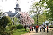
Sights
- Harzer Schmalspurbahn – a narrow gauge railway that leads from Wernigerode to the Brocken (1,141 m or 3,743 ft), the highest peak in the Harz Mountains, and then goes to Nordhausen to the south of the Harz mountains. The second highest peak, Wurmberg (971 m or 3,186 ft), is accessible by cable car from Braunlage which is connected by bus to Wernigerode. Wernigerode has numerous museums, galleries, libraries, monuments and parks.[specify]
- Armeleuteberg – hill with an Emperor Tower and forest inn.
-
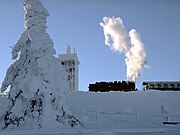 Top of the Brocken with the Brockenbahn, which starts in Wernigerode
 -
 Chape lSt. Pantaleon and Anna of Wernigerode Castle
 -
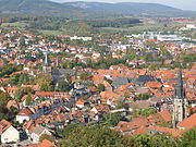 View over the old town of Wernigerode
 -
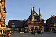 Town hall
 -
-
 Wernigerode campus is part of the Hochschule Harz
 -
 The Hasseröder brewery in Wernigerode
 -
 Town hall and Christmas market at night
 -
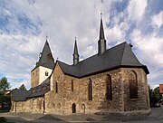 The St. Johannes Church
 -
 The Catholic Church
 -
 Typical old town houses

_2017.jpg)

,_by_Klugschnacker_in_Wikipedia_(9).JPG)
.jpg)


Culture
Wernigerode is the home of the choir Rundfunk-Jugendchor Wernigerode.
Natural monuments
- Steinerne and Kleine Renne, and the nearby well of Wernigeröder Bürgerbrunnen
- Ottofels, rock formation with extensive views over the Harz
- Mönchsbuche, a protected beech on the old monk's way
Sport
Wernigerode hosts the Brocken Marathon each October. Wernigerode's most supported club is Einheit Wernigerode, who competes in the NOFV-Oberliga, and recently qualified for the DFB-Pokal, eventually losing to SC Paderborn 07 0-10. Wernigerode also has had an American Football club, The Mountain Tigers, since 1993. During the last 19 years this team has played in Germany's Oberliga 4 and Regionaliga 3. Since its inception, it has been a mainstay for American football in the Harz region.
Twin towns – sister cities
Wernigerode is twinned with:[10]
 Carpi, Italy (1964)
 Cisnădie, Romania (2002)
 Hội An, Vietnam (2013)
 Neustadt an der Weinstraße, Germany (1998)
Notable people
- Henry Ernest of Stolberg-Wernigerode (1716–1786), canon, dean and author of many hymns
- Christian Gottlieb Kratzenstein (1723–1795), physician and engineer
- Christian Frederick of Stolberg-Wernigerode (1746–1824), Count of Stolberg-Wernigerode
- Martin Heinrich Klaproth (1743–1817), chemist
- Henry of Stolberg-Wernigerode (1772–1854), Count of Stolberg-Wernigerode
- Anton of Stolberg-Wernigerode (1785–1854), chief minister in Magdeburg, governor in the Prussian Province of Saxony and Prussian Minister of State
- Heinrich Karl Beyrich (1796–1834), botanist
- Gustav Eduard von Hindersin (1804–1872), Prussian general
- Rudolf Stammler (1856–1938), jurist
- Otto Herfurth (1893–1944), general
- Wilhelm Bittrich (1895–1979), Waffen-SS General
- Friedrich Lütge (1901–1968), historian and economist
- Franz Nicklisch (1906–1975), actor
- Rolf Hermichen (1918–2014), fighter ace
- Konrad Sasse (1926–1981), musicologist
- Karl Oppermann (1930-2022), painter
- Rudolf Dannhauer (born 1934), cross-country skier
- Waldtraut Lewin (1937–2017), stage director
- Wolf Barth (1942–2016), mathematician
- Monika Wulf-Mathies (born 1942), politician
- Karin Rüger-Schulze (born 1944), track and field athlete
- Irene Ellenberger (born 1946), architect
- Lutz Unger (born 1951), swimmer
- Karsten Brandt (born 1958), cross-country skier
- Caspar René Hirschfeld (born 1965), composer
- Bernhard Schneyer (born 1968), composer
- Guido Fulst (born 1970), racing cyclist
- Jens Baxmann (born 1985), ice hockey player
- Nils Petersen (born 1988), footballer
- Christopher Grotheer (born 1992), skeleton racer
Notes
- ^ Bürgermeisterwahlen in den Gemeinden, Endgültige Ergebnisse, Statistisches Landesamt Sachsen-Anhalt, accessed 10 November 2022.
- ^ "Bevölkerung der Gemeinden – Stand: 31. Dezember 2022" (PDF) (in German). Statistisches Landesamt Sachsen-Anhalt. June 2023.
{{cite web}}: CS1 maint: unrecognized language (link) - ^ "Stadt Wernigerode". 21 February 2024.
- ^ 4.0 4.1 4.2 Chisholm 1911.
- ^ Hauptsatzung Stadt Wernigerode Archived 2012-04-15 at the Wayback Machine (PDF; 88 KB); accessed on 30 March 2011
- ^ Klimaklassifikation nach E. Neef. Siehe m-forkel.de: Klimazonen Archived 2015-04-23 at the Wayback Machine
- ^ "World Meteorological Organization Climate Normals for 1991–2020". World Meteorological Organization Climatological Standard Normals (1991–2020). National Oceanic and Atmospheric Administration. Archived from the original on 12 October 2023. Retrieved 12 October 2023.
- ^ "Ukendt Runden´s profil". MyHeritage.com. Retrieved 14 April 2018.
- ^ "Home". www.gerhart-hauptmann-gymnasium.de. Retrieved 14 April 2018.
- ^ "Partnerstädte". wernigerode.de (in Deutsch). Wernigerode. Retrieved 17 February 2021.
References
Attribution:
- This article incorporates text from a publication now in the public domain: Chisholm, Hugh, ed. (1911). "Wernigerode". Encyclopædia Britannica. Vol. 28 (11th ed.). Cambridge University Press. p. 524.
External links
Towns and municipalities in the district of Harz | ||
|---|---|---|
Town of Wernigerode | ||
|---|---|---|
- CS1 maint: unrecognized language
- Webarchive template wayback links
- CS1 Deutsch-language sources (de)
- Short description with empty Wikidata description
- Use dmy dates from July 2024
- Articles with invalid date parameter in template
- Coordinates not on Wikidata
- Towns in Saxony-Anhalt
- Pages with German IPA
- Articles containing German-language text
- Wikipedia articles incorporating a citation from the 1911 Encyclopaedia Britannica with Wikisource reference
- Wikipedia articles incorporating text from the 1911 Encyclopædia Britannica
- Commons link is defined as the pagename
- Wernigerode
- Towns in the Harz