
Barnim
This article needs additional citations for verification. (March 2013) |
Barnim | |
|---|---|
 Flag  Coat of arms | |
| <mapframe zoom="6" frameless="1" align="center" height="250" latitude="52.53" longitude="13.33" width="270">{ "type": "ExternalData", "service": "geoshape", "properties": { "stroke-width": 1 }, "query": " SELECT ?id (if(?id = wd:, '#C12838', '#07c63e') as ?fill) (if(BOUND(?link), concat('', ?idLabel, ''), ?idLabel) as ?title) WHERE { { ?id p:P31/ps:P31/wdt:P279* wd:Q22865 . hint:Prior hint:gearing 'forward' } UNION { ?id p:P31/ps:P31/wdt:P279* wd:Q106658 . hint:Prior hint:gearing 'forward' } ?id p:P131 ?locst . ?locst ps:P131/wdt:P131* wd:Q1208. hint:Prior hint:gearing 'forward' MINUS { ?locst pq:P582 [] } MINUS { ?id wdt:P576 [] } SERVICE wikibase:label { bd:serviceParam wikibase:language 'en' . ?id rdfs:label ?idLabel . } OPTIONAL {?link schema:about ?id . ?link schema:isPartOf <https://en.wikipedia.org/> . } } GROUP BY ?id ?link ?idLabel "}</mapframe> | |
| Country | Germany |
| State | Brandenburg |
| Capital | Eberswalde |
| Government | |
| • District admin. | Daniel Kurth (SPD) |
| Area | |
| • Total | 1,494 km2 (577 sq mi) |
| Population (31 December 2022)[1] | |
| • Total | 191,849 |
| • Density | 130/km2 (330/sq mi) |
| Time zone | UTC+01:00 (CET) |
| • Summer (DST) | UTC+02:00 (CEST) |
| Vehicle registration | BAR, BER, EW |
| Website | www.barnim.de |
Barnim (German pronunciation: [ˈbaʁnɪm] ) is a district in Brandenburg, Germany. It is bounded by (from the east and clockwise) Poland, the district of Märkisch-Oderland, the city state of Berlin and the districts of Oberhavel and Uckermark.
History
The name "Barnim" emerged in the 13th century and was applied to a large forest region east of the Havel and north of the Spree on the homonymous plateau, where noblemen used to hunt. The present district is roughly identical with, but somewhat smaller than this historical region.
The district was established in 1993 by merging the former districts of Bernau and Eberswalde.
Geography
Barnim extends from the Oder River to the outskirts of Berlin. The Oder River forms the eastern border. From here the Oder Havel Canal (connecting Oder and Havel) and the historical Finow Canal lead westwards to Eberswalde and beyond. The portions north of these artificial waterways are called Schorfheide. This is a forest region with several large lakes, e.g. Werbellinsee (8 km2), Grimnitzsee (8 km2) and Parsteiner See (10 km2). The Schorfheide is a UNESCO Biosphere Reserve and houses several rare animals like the white-tailed eagle, greater spotted eagle, osprey, black stork, European beaver and Eurasian otter.
Demography
-
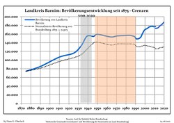 Development of Population since 1875 within the Current Boundaries (Blue Line: Population; Dotted Line: Comparison to Population Development of Brandenburg state; Grey background: Time of Nazi rule; Red background: Time of communist rule)
 -
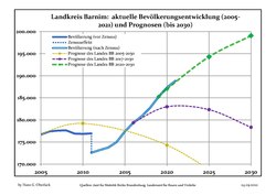 Recent Population Development and Projections (Population Development before Census 2011 (blue line); Recent Population Development according to the Census in Germany in 2011 (blue bordered line); Official projections for 2005-2030 (yellow line); for 2014-2030 (red line); for 2017-2030 (scarlet line)
|
|
|
Coat of arms

The coat of arms of the district resembles the coat of arms of the former district Oberbarnim. The only difference is that the old one had a silver top half and a red bottom half, while the current one is split into four parts and in the right half exchanged red and silver. The eagle in the top half is the eagle of Brandenburg.
Towns and municipalities
<imagemap>File:Municipalities in BAR.png | 300px|thumb|Clickable map of towns and municipalities in the district poly 96 296 110 290 96 283 90 249 83 243 82 248 73 248 83 255 64 274 53 268 43 278 62 285 70 295 77 288 83 297 Ahrensfelde poly 164 74 173 72 163 63 170 48 159 39 150 51 144 61 141 76 153 72 Althüttendorf poly 64 272 61 237 39 234 43 224 37 214 27 195 48 187 49 204 62 196 75 193 81 182 83 190 74 196 85 213 93 217 102 222 100 248 94 247 89 260 85 248 87 241 81 246 73 247 80 254 Bernau bei Berlin poly 102 217 106 211 108 183 109 168 103 150 96 146 85 156 81 151 92 136 87 137 63 149 77 169 70 191 79 181 83 191 94 195 Biesenthal poly 138 188 126 173 143 173 149 164 150 155 169 152 178 166 173 181 Breydin poly 151 116 161 114 169 102 163 93 143 97 141 90 129 93 146 103 Britz poly 178 124 164 120 169 104 162 90 150 96 135 94 128 92 153 71 165 75 184 67 199 60 213 54 218 57 215 66 222 76 230 78 231 83 219 98 210 112 202 123 197 114 192 126 Chorin poly 110 161 103 145 118 145 116 130 119 113 132 122 139 121 141 112 156 119 170 102 168 124 180 124 180 131 191 132 188 143 182 144 170 141 168 155 150 156 150 167 140 159 Eberswalde poly 103 22 124 24 132 22 136 33 144 30 149 20 170 23 172 8 183 2 153 0 108 8 154 0 154 7 119 12 105 10 Friedrichswalde poly 175 161 194 154 199 145 205 137 191 131 190 141 182 150 177 141 165 143 Hohenfinow poly 106 87 98 89 97 75 89 44 78 33 107 31 114 23 127 26 138 32 143 32 150 18 163 22 158 40 156 43 148 58 143 78 127 94 123 81 Joachimsthal poly 215 139 205 120 212 105 222 113 222 121 215 127 Liepe poly 249 95 251 75 249 57 274 57 283 95 Lunow-Stolzenhagen poly 56 155 63 148 86 138 95 135 84 122 93 119 89 106 79 107 77 122 59 116 64 128 53 129 48 140 40 147 Marienwerder poly 107 184 103 164 146 158 146 171 128 173 Melchow poly 210 141 210 136 199 114 184 127 175 126 Niederfinow poly 230 126 258 118 259 110 244 109 246 95 249 92 249 87 223 86 215 105 Oderberg poly 46 277 43 269 46 260 48 244 39 241 25 237 33 229 52 234 65 238 68 271 55 265 Panketal poly 249 86 254 72 253 68 233 62 227 78 230 84 230 87 Parsteinsee poly 100 218 95 190 78 187 72 196 89 216 Rüdnitz poly 65 117 43 109 26 103 38 95 32 86 23 82 9 90 7 84 22 76 19 73 6 77 10 64 23 57 41 52 49 45 54 42 79 33 92 57 99 81 97 90 110 90 124 85 133 101 148 108 140 110 133 124 128 116 119 115 114 134 118 142 104 151 100 146 82 156 85 148 96 132 92 127 96 115 86 103 76 121 Schorfheide poly 100 216 109 210 106 183 125 172 137 189 124 194 133 207 115 222 Sydower Fließ poly 13 256 4 242 11 233 3 227 7 209 7 191 4 159 17 148 43 147 46 135 42 127 28 110 55 115 68 126 48 129 40 145 58 154 66 150 74 171 74 192 63 190 49 198 50 186 40 186 26 200 39 219 43 231 36 233 Wandlitz poly 102 294 126 268 159 254 168 238 168 221 139 235 132 206 117 219 100 215 105 248 91 250 Werneuchen poly 171 72 162 61 174 50 194 42 206 59 Ziethen poly 175 297 176 174 297 174 296 296 Brandenburg
desc bottom-right </imagemap>
| Amt-free towns | Ämter | |
|---|---|---|
|
|
||
| 1seat of the Amt; 2town | ||
References
- ^ "Bevölkerungsentwicklung und Bevölkerungsstandim Land Brandenburg Dezember 2022" (PDF). Amt für Statistik Berlin-Brandenburg (in German). June 2023.
{{cite web}}: CS1 maint: unrecognized language (link) - ^ Detailed data sources are to be found in the Wikimedia Commons.Population Projection Brandenburg at Wikimedia Commons
External links
![]() Media related to Barnim at Wikimedia Commons
Media related to Barnim at Wikimedia Commons
- Official website (in German)
| Urban districts | |
|---|---|
| Rural districts | |
- CS1 maint: unrecognized language
- Articles needing additional references from March 2013
- All articles needing additional references
- Short description with empty Wikidata description
- Pages using infobox settlement with no coordinates
- Districts of Brandenburg
- Pages with German IPA
- Commons category link is locally defined
- Articles with German-language sources (de)
- Coordinates not on Wikidata
- Barnim