
Guern
Guern
Gwern | |
|---|---|
 The town hall in Guern | |
 Guern  Guern | |
| Coordinates: 48°01′53″N 3°05′26″W / 48.0314°N 3.0906°W | |
| Country | France |
| Region | Brittany |
| Department | Morbihan |
| Arrondissement | Pontivy |
| Canton | Pontivy |
| Intercommunality | Pontivy Communauté |
| Government | |
| • Mayor (2023–2026) | Stéphanie L'Hostis-Le Diagon[1] |
| Area 1 | 47.01 km2 (18.15 sq mi) |
| Time zone | UTC+01:00 (CET) |
| • Summer (DST) | UTC+02:00 (CEST) |
| INSEE/Postal code | 56076 /56310 |
| Elevation | 67–188 m (220–617 ft) |
| 1 French Land Register data, which excludes lakes, ponds, glaciers > 1 km2 (0.386 sq mi or 247 acres) and river estuaries. | |
Guern (French pronunciation: [ɡɛʁn]; Breton: Gwern) is a commune in the Morbihan department of Brittany in north-western France.[2]
Population
Inhabitants of Guern are called in French Guernates.
|
| ||||||||||||||||||||||||||||||||||||||||||||||||||||||||||||||||||||||||||||||||||||||||||||||||||||||||||||||||||
<graph>{"legends":[],"scales":[{"type":"linear","name":"x","zero":false,"domain":{"data":"chart","field":"x"},"range":"width","nice":true},{"clamp":true,"type":"linear","name":"y","domain":{"data":"chart","field":"y"},"domainMin":0,"zero":false,"range":"height","nice":true},{"domain":{"data":"chart","field":"series"},"type":"ordinal","name":"color","range":"category10"}],"version":2,"marks":[{"type":"line","properties":{"hover":{"stroke":{"value":"red"}},"update":{"stroke":{"scale":"color","field":"series"}},"enter":{"y":{"scale":"y","field":"y"},"x":{"scale":"x","field":"x"},"stroke":{"scale":"color","field":"series"},"strokeWidth":{"value":2.5}}},"from":{"data":"chart"}}],"height":170,"axes":[{"type":"x","title":"Year","scale":"x","format":"d","properties":{"title":{"fill":{"value":"#54595d"}},"grid":{"stroke":{"value":"#54595d"}},"ticks":{"stroke":{"value":"#54595d"}},"axis":{"strokeWidth":{"value":2},"stroke":{"value":"#54595d"}},"labels":{"align":{"value":"right"},"angle":{"value":-45},"fill":{"value":"#54595d"}}},"grid":false},{"type":"y","title":"Population","scale":"y","format":",d","properties":{"title":{"fill":{"value":"#54595d"}},"grid":{"stroke":{"value":"#54595d"}},"ticks":{"stroke":{"value":"#54595d"}},"axis":{"strokeWidth":{"value":2},"stroke":{"value":"#54595d"}},"labels":{"fill":{"value":"#54595d"}}},"grid":true}],"data":[{"format":{"parse":{"y":"integer","x":"integer"},"type":"json"},"name":"chart","values":[{"y":2500,"series":"y","x":1793},{"y":2237,"series":"y","x":1800},{"y":3058,"series":"y","x":1806},{"y":3079,"series":"y","x":1821},{"y":3386,"series":"y","x":1831},{"y":3468,"series":"y","x":1836},{"y":3327,"series":"y","x":1841},{"y":3619,"series":"y","x":1846},{"y":3564,"series":"y","x":1851},{"y":3280,"series":"y","x":1856},{"y":3229,"series":"y","x":1861},{"y":3341,"series":"y","x":1866},{"y":2654,"series":"y","x":1872},{"y":2709,"series":"y","x":1876},{"y":2734,"series":"y","x":1881},{"y":2766,"series":"y","x":1886},{"y":2746,"series":"y","x":1891},{"y":2677,"series":"y","x":1896},{"y":2787,"series":"y","x":1901},{"y":2863,"series":"y","x":1906},{"y":2714,"series":"y","x":1911},{"y":2524,"series":"y","x":1921},{"y":2575,"series":"y","x":1926},{"y":2655,"series":"y","x":1931},{"y":2466,"series":"y","x":1936},{"y":2440,"series":"y","x":1946},{"y":2144,"series":"y","x":1954},{"y":1896,"series":"y","x":1962},{"y":1670,"series":"y","x":1968},{"y":1555,"series":"y","x":1975},{"y":1534,"series":"y","x":1982},{"y":1409,"series":"y","x":1990},{"y":1398,"series":"y","x":1999},{"y":1448,"series":"y","x":2009},{"y":1362,"series":"y","x":2014},{"y":1314,"series":"y","x":2020}]}],"width":340}</graph> | |||||||||||||||||||||||||||||||||||||||||||||||||||||||||||||||||||||||||||||||||||||||||||||||||||||||||||||||||||
| Source: EHESS[3] and INSEE (1968-2020)[4] | |||||||||||||||||||||||||||||||||||||||||||||||||||||||||||||||||||||||||||||||||||||||||||||||||||||||||||||||||||
Geography
The village centre is located 10 km (6.2 mi) southwest of Pontivy. The Sarre river flows through the village. The main settlements are the village centre, Quelven and Locmeltro. In the village of Quelven is the basilica Notre-Dame de Quelven.
Map

Gallery
-
 Basilica Notre-Dame de Quelven
 -
 Chapel Saint Meldéoc of Locmeltro
 -
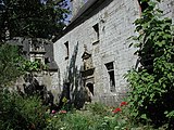 Manor of Menorval
 -
 Column of Locmeltro


See also
References
- ^ "Répertoire national des élus: les maires" (in français). data.gouv.fr, Plateforme ouverte des données publiques françaises. 30 November 2023.
- ^ INSEE commune file
- ^ Des villages de Cassini aux communes d'aujourd'hui: Commune data sheet Guern, EHESS (in French).
- ^ Population en historique depuis 1968, INSEE
External links
Wikimedia Commons has media related to Guern.
- Official site (in French)
- Base Mérimée: Search for heritage in the commune, Ministère français de la Culture. (in French)
- Mayors of Morbihan Association (in French)
This Morbihan geographical article is a stub. You can help Wikipedia by expanding it. |
Categories:
- CS1 français-language sources (fr)
- Articles with French-language sources (fr)
- Short description with empty Wikidata description
- Use dmy dates from August 2023
- Articles with invalid date parameter in template
- Coordinates not on Wikidata
- Pages with French IPA
- Articles containing Breton-language text
- Pages using Lang-xx templates
- Commons category link is the pagename
- Communes of Morbihan
- Morbihan geography stubs