
Ubbergen
Ubbergen | |
|---|---|
Village and former municipality | |
 Church in Beek | |
 Flag  Coat of arms | |
.svg) Location in Gelderland | |
 Ubbergen Location in the province of Gelderland  Ubbergen Ubbergen (Netherlands) | |
| Coordinates: 51°50′N 5°55′E / 51.833°N 5.917°E | |
| Country | Netherlands |
| Province | Gelderland |
| Municipality | Berg en Dal |
| Area | |
| • Total | 0.78 km2 (0.30 sq mi) |
| Elevation | 13 m (43 ft) |
| Population (2021)[1] | |
| • Total | 475 |
| Demonym | Ubberger |
| Time zone | UTC+1 (CET) |
| • Summer (DST) | UTC+2 (CEST) |
| Postcode | 6574[1] |
| Area code | 024 |
| Website | www |
Ubbergen (Dutch pronunciation: [ʏˈbɛrɣə(n)] ) is a village and former municipality in the eastern Netherlands, in the province of Gelderland. On 1 January 2015 it merged into the enlarged municipality of Groesbeek, renamed Berg en Dal from 1 January 2016.[3]
Notable people
Notable people who were born in Ubbergen include:
- Don Burgers (1932–2006), politician for the KVP and the CDA
- Amber (1970), Dutch-German singer, songwriter and music producer
- Yelmer Buurman (1987), professional racing driver
Gallery
-
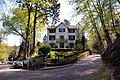 Villa 'De Maartenshof' on the Rijkstraatweg
 -
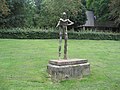 Statue of Nescio (1991) on the Rijksstraatweg
 -
 The school building of Notre Dame des Anges
 -
 'De Refter': monumental building complex
 -
 The 'Bronnenbos': a carr in Ubbergen


References
- ^ 1.0 1.1 1.2 "Kerncijfers wijken en buurten 2021". Central Bureau of Statistics. Retrieved 19 March 2022.
- ^ "Postcodetool for 6573CL". Actueel Hoogtebestand Nederland (in Nederlands). Het Waterschapshuis. Retrieved 18 July 2014.
- ^ "Gemeente Berg en Dal". internetgemeentegids.nl (in Nederlands). Retrieved 4 July 2024.
External links
 Media related to Ubbergen at Wikimedia Commons
This Gelderland location article is a stub. You can help Wikipedia by expanding it. |
Categories:
- CS1 Nederlands-language sources (nl)
- Short description with empty Wikidata description
- Coordinates not on Wikidata
- Pages with Dutch IPA
- Commons category link is defined as the pagename
- Municipalities of the Netherlands disestablished in 2015
- Former municipalities of Gelderland
- Populated places in Gelderland
- Geography of Berg en Dal (municipality)
- Gelderland geography stubs